Territori Cerdanya 360 is a circular walking route that covers the rich heritage of Cerdanya passing through traditional paths, villages, valleys and unique places.
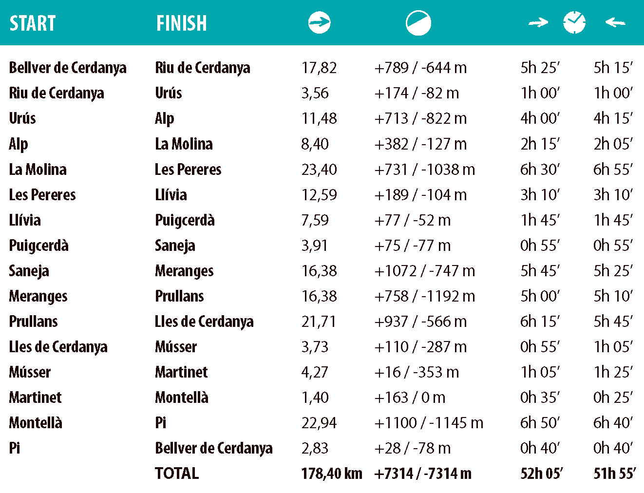
With a total route of 178 km and more than 14.628 m of accumulated difference in altitude, we are in a medium and high mountain environment, with heights ranging from 960 m to 2.257 m.
The options for stages are very varied, with different types of accommodation.
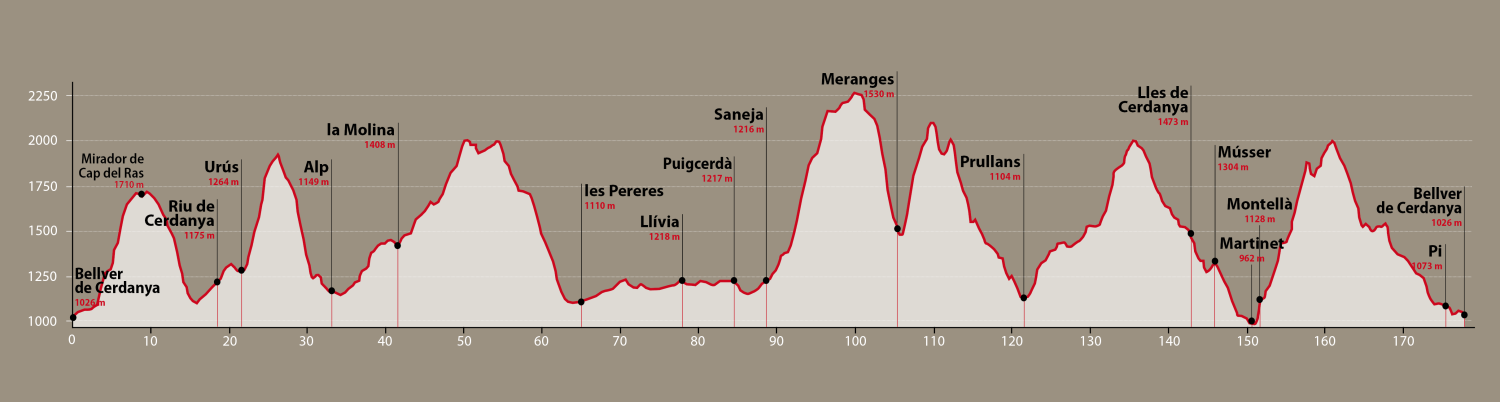
Route map

Villages and places of interest
Puigcerdà (1.202 m)
The capital of Cerdanya is a good starting point to start our adventure. Puigcerdà has a privileged situation, as it borders by France. Among the most emblematic tourist spots, the Campanar, located in the shopping center, which is the starting point of a tourist route where you can enjoy vestiges of the Romanesque, Gothic and Neo-Gothic periods, such as the l’església de Sant Domènec or the ‘former cloistered convent, now converted into the Museu Cerdà. It is also worth noting the Llac de Puigcerdà and the Parc Shierbeck, where you can enjoy the landscape and nature.
Guils de Cerdanya (1.385 m)
On the border with French Cerdanya, the church of Sant Esteve de Guils stands out. During the winter, we highlight the Guils – Fontanera area, where you can go cross-country skiing and snowshoeing at the resort of the same name, and where the herds graze in the summer. The Fontanera Gathering is held in mid-August.
La Feixa (2.160 m)
La Feixa, belonging to the municipality of Ger, is a plan located in a privileged environment, which enjoys special protection:
the Pla d’Espais d’Interès Natural (PEIN) and the Tossa Plana de Lles – Puigpedrós. Here we find a small refuge, intimate and welcoming.
Meranges
Meranges is located in the valley of the river Duran and integrates the villages of Meranges and Girul. Many hikers visit the highest areas of the town, where the Malniu lake and the Engorgs glacial circus stand out, as well as the ascent to the Puigpedrós. As a point of interest, visitors can admire the portal of the Romanesque church of Meranges.
Prullans (1.096 m)
Prullans is a living witness of history: the oldest signs correspond to a settlement from the Bronze Age and the dolmens of Orèn. In addition, it preserves the tower of the Baron of Prullans and is notable the cave of Anes (shared with Bellver), as well as the fortified farmhouse of Oren. The location of the village offers a unique view of the Sierra del Cadí.
Lles de Cerdanya (1.470 m)
Located on a landing facing south, on the slope of the mountain. It is arranged around the parish church of Sant Pere, of a nave, with a cumbersome square bell tower with a pyramidal roof. There are some apartments and villas and some old houses such as Cal Ferrer and Cal Peremptori. In the center there is also the chapel of Mare de Déu del Roser, popularly called Benefici.
Músser (1.305 m)
Village in the municipality of Lles de Cerdanya located at 1.305 m above sea level on the left bank of the Arànser river, on the granite ridge that separates Cerdanya from Alt Urgell. The parish church of Sant Fructuós, of Romanesque origin (11th century), stands out.
Martinet (950 m)
Martinet, is a town on the banks of the Segre River, with many and varied tourist attractions: Casa del Riu converted into an information office and space for exhibitions; Parc dels Búnquers, which is presented as a different proposal to recover historical memory.
Montellà (1.100 m)
A village perched on the left side of the Segre, it is one of the best natural viewpoints in Cerdanya. The parish church of Sant Serni is mentioned as early as 839.
Nas (1.225 m)
Nas located between the Pi and Ridolaina valleys, on the so-called Nas plain, northern buttress of the Avetosa mountain range.
Pi (1.080 m)
Located to the left of the torrent of the same name, the beauty of its valley stands out. The current parish of Santa Eulàlia is of Romanesque origin, but was almost completely reformed in the 18th century.
Bellver de Cerdanya (1.060 m)
It is located on a hill that dominates Batllia from its geographical center. The Segre runs at its foot and the town is very well connected, being located at the crossroads of the Baga (LP-4033) and Solana (N-260) roads. It is interesting to stop and contemplate the architecture offered by the old town of Bellver de Cerdanya, which has been restored to give it back its medieval air. In the Plaça Major, surrounded by porches, we must highlight the old customs house, today Casa de la Vila. Next to the square is the church of Sant Jaume and Santa Maria, which belongs to the Catalan Gothic style. In Plaça del Portal, in the fortified town, there is the Prison tower, which served as a defense for the walled town.
Talló (1.060 m)
It is a small nucleus with a strong historical tradition both for being a capital place of worship and burial, for its gathering and as the seat of an Augustinian canonry (Sancta Maria Tollonensis). Currently, Santa Maria de Talló is the most monumental example of Cerdà Romanesque.
Coborriu de Bellver (1.080 m)
It is located at the entrance to the Ingla valley, on the left bank of the Segre, where the Romanesque church of Sant Serni stands out, where there was a mill. It was consecrated in the s. XII, by the bishops of La Seu and Elna (Rosselló), which would denote its importance as a control point of the Coll de Pendís.
Bor (1.100 m)
It is located in the middle of the Fou de Bor and Bavosa streams, on the left bank of the Segre. It integrates various speleological, architectural and gastronomic places of interest, such as the Fou cave and the Romanesque church of Sant Marcel.
Pedra (1.120 m)
It is located at the foot of the serrat dels Gats, in the Pedra valley, with the church of Sant Julià on top of a rocky outcrop that dominates the Batllia plain. Specifically, this temple is part of the examples of primitive Romanesque (10th-11th centuries) in the region.
Riu de Cerdanya (1.179 m)
Small town at the foot of Cadí and Moixeró, the church of Sant Joan Baptista and its baroque altar stand out. also the fountain, located in the square where the Ball of the Washerwomen is danced for the main festival.
Urús (1.263 m)
Pronounced Grus by the people of the country, it is located in tramuntana and is located between the Castellar hill and the Mirabò pass.
At its exit, we find the Freda fountain, on the way to Riu de Pendís. From here, a track leads to Puig d’Urús, where there is the hermitage of Sant Grau or Sant Pau del Puig d’Urús. A few meters further on, the base of an ancient medieval watchtower is preserved, which must have controlled the Grau de l’Ós torrent, and today it faces the northern mouth of the Túnel del Cadí. The track continues on the other side to the Cortal d’en Vidal meadow (1.650 m), where we find a forest shelter in good condition.
Alp (1.158 m)
The town of Alp is located in the ridge of the mountain, at the NW end of the term and to the left of the river of its name. The parish church of Sant Pere is of Romanesque origin, but quite modified. Alp is the capital of the municipality that bears his name and houses the ski resorts of La Molina and Masella.
La Molina (1.400 m)
La Molina is a population entity in the municipality of Alp. Located at the exit of the Toses railway tunnel, at the head of the river Alp (or Riera de la Molina). The population has grown around the ski resort of the same name, La Molina. Very close to the town, a 10-minute walk, is the dolmen of Paborda.
Queixans (1.125 m)
Queixans is the largest population entity in the municipality of Fontanals de Cerdanya. The church of Sant Cosme and Sant Damià stands out, in addition very close to the town we find the Arborètum de Fontanals, a botanical garden in conditioned land, with the aim of exhibiting tree species or plant varieties.
Les Pereres (1.140 m)
Les Pereres is a town in the municipality of Fontanals de Cerdanya. The Romanesque church of Sant Esteve stands out..
Llívia (1.224 m)
From the 17th century it became a Spanish enclave on French territory, which has given it a special tourist attraction. It is also a place that has witnessed the passage of numerous armies (Romans, Visigoths, Arabs and Franks, occasionally, and French on numerous occasions).
Among the cultural and recreational offer, the visit to the Municipal Museum, where you can see some of the most emblematic pieces of the famous Esteva S. XV Pharmacy, as well as the church of Mare de Déu dels Àngels, an exceptional building for its large dimensions and fortified appearance, also for being located on top of the remains of the ancient Roman forum of Iulia Lybica, whose structures would have been used as the foundation of the church.
How to do the route
Technical data
Total distance: 178.40 km
Minimum height: 960 m
Maximum height: 2.257 m
Total positive elevation difference: 7.314 m
Total negative difference: – 7.314 m
Route
Incline
Services
The best way to follow the route is accompanied by a mountain guide from our region.
If you need transport, you can consult all the public transport services in the region.
In the towns through which the route passes you will find a variety of shops.